


- About
-
Upazila Parishad
Upazila Parishad meeting minutes
-
উপজেলা পরিষদের ২০২৪-২০২৫ অর্থ বছরের মাসিক সভার কার্যবিবরণী
-
Minutes of the monthly meeting of the Upazila Parishad for the financial year 2021-2022
-
Minutes of the monthly meeting of the Upazila Parishad for the financial year 2022-2023
-
Minutes of the monthly meeting of the Upazila Parishad for the financial year 2023-2024
Upazila Parishad Five Year Plan
Upazila Parishad committee meeting
-
Committee on Law and Order
-
Development of communication and physical infrastructure
-
Agriculture and Irrigation
-
Secondary and Madrasa Education
-
Primary and mass education
-
স্বাস্থ্য ও পরিবার কল্যাণ
-
Youth and Sports Development
-
Women and Child Development
-
social service
-
freedom fighter
-
Fisheries and Livestock
-
Rural Development and Cooperatives
-
culture
-
Forests and environment
-
Market price observation, monitoring and regulation
-
Finance, budgeting, planning and local resource mobilization
-
Public health, sanitation and clean drinking water supply
-
উপজেলা পরিষদের ২০২৪-২০২৫ অর্থ বছরের মাসিক সভার কার্যবিবরণী
- Administration
- Municipality
- Govt. Offices
- Different Institutions
- E-Service
- Gallery
-
About
Upazila Introduction
History-Tradition
Geographical and Economic
Other
-
Upazila Parishad
Functions of Upazila Parishad
Upazila Parishad Chairman
Upazila Parishad meeting minutes
- উপজেলা পরিষদের ২০২৪-২০২৫ অর্থ বছরের মাসিক সভার কার্যবিবরণী
- Minutes of the monthly meeting of the Upazila Parishad for the financial year 2021-2022
- Minutes of the monthly meeting of the Upazila Parishad for the financial year 2022-2023
- Minutes of the monthly meeting of the Upazila Parishad for the financial year 2023-2024
Upazila Parishad budget
Upazila Parishad Five Year Plan
Annual Report (ADP, Development and Revenue
Annual Development Plan
Annual Financial Statements
Upazila Parishad committee meeting
- Committee on Law and Order
- Development of communication and physical infrastructure
- Agriculture and Irrigation
- Secondary and Madrasa Education
- Primary and mass education
- স্বাস্থ্য ও পরিবার কল্যাণ
- Youth and Sports Development
- Women and Child Development
- social service
- freedom fighter
- Fisheries and Livestock
- Rural Development and Cooperatives
- culture
- Forests and environment
- Market price observation, monitoring and regulation
- Finance, budgeting, planning and local resource mobilization
- Public health, sanitation and clean drinking water supply
Asset Statement (Register)
Citizen Charter of Upazila porishad
-
Administration
Upazila Nirbahi Officer
কর্মচারীবৃন্দ
About the organization
Services and other
-
Municipality
At one glance, Narail Municipality
Activities
-
Govt. Offices
Law and order matters
Engineering and communication
Health and family planning
Agriculture and food related issues
Education related
About Human Resources Development
-
Different Institutions
Educational Institution
Marriage Registrars List
Private companies
- E-Service
- Gallery
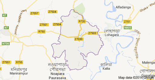
Click to view Narail Sadar Upazila in Google Map.
Geographical identity of Narail Sadar Upazila
Location and Land Identification
Narail Sadar Upazila is located on the banks of the beautiful picturesque river Chitra. Chitra-Kajla and several canals of Shaila-Sunibir Narail Sadar Upazila fertile plain. River-Nala-Khal-bills and fertile agricultural and pastoral areas have been characterized by Narail Sadar upazila. The livelihood of the population of this population is agricultural. Paddy, jute, sugarcane, wheat, corn, vegetables and various sesame seeds are easily produced in the fertile plain.
Geographical location
Narail sadar is situated 23 ° 02' and 23 ° 17' north latitudes and 89223˝ and 89˙37˝ east longitude.
Borders
Mohammadpur and Shalikha upazilas on the north, Magura. Lohagora upazila, Narail before Kaliya upazila on the south, Narail and Abhaynagar upazilas, Jessore and Baghparpara upazila on the west, Jessore
Volume
381.75 square kilometers


Planning and Implementation: Cabinet Division, A2I, BCC, DoICT and BASIS
Technical Assistance:
![]()
Developed By:
